Searching Tip – Use the least amount of words necessary, and choose the correct name from the results. (e.g. “Jones,” not “T Jones,” “T. Jones,” “TS Jones,” “T.S. Jones,” “Ted Jones,” etc. – just “Jones.”)
The earliest settlers that located on Dead Ox Flat were the Applegate Brothers, which consisted of James C., John P., and our most esteemed neighbor Uncle Sammie. They crossed the plains from Indiana in 1853 and took up their permanent residence at Douglas County, Oregon, where they gradually drifted back to Boise Basin and participated in the great boom of ’64. Cattle raising was the principal industry of their various occupations. They located on the Payette river below Falk’s store in the latter ’60s and laid the foundation of their future career as stockmen.
In the spring of 1871, they moved their cattle to the Dead Ox Flat country. James C. did most of the riding and located at what is now known as Mesquite. He was assisted by his brothers in the general roundup.
James was known by all of the early pioneers for funny stories and jokes. His various stories and good-natured ways led to the naming of his ranch, The ‘Game Cock.’ This place was the headquarters for the roundup, and travelers always found a hearty welcome, and the latch string hung out to all who chanced to be passing. James Applegate died of asthma and is buried near Falk’s Store.
Their prosperity as cattle raisers was profitable from the first, and continued for many years, but the range of their ‘Great Ranch,’ including the territory from Malheur Butte to Olds Ferry was gradually taken up by the settlers, thus reducing the extent of grazing and limiting the industry. No doubt they may have felt a little hard toward these new comers.
John P. Applegate lived on Monroe Creek and ran his cattle on the Dead Ox Flat, being present and riding during the roundup.
Samuel H. Applegate moved his family in 1884 from the Applegate ranch on the Payette river to his present place on Dead Ox Flat where he now resides. Mr. Applegate’s influence for integrity has been of inestimable value. His personal example of right thinking and living is a worthy pattern to follow.
Mr. Applegate found game in abundance when he came to the country, deer, elk, and bear. They lived at times in fear of the Indians who prowled about and threatened to become troublesome. In 1878, a party of Indians tore down a cabin belonging to James Applegate, which they used to make a raft to cross Snake River.
The cabin had been built one mile below the ferry. It was made of willows and balm logs which had been cut at Buttermilk Slough. This band of Indians was known as the Sheep Heads, and were the renegades of various other tribes.
Their headquarters were in Indian and Council valleys. Few people were killed, but cattle and horses were often slaughtered or driven away.
In 1873, Dennis Dyer came from Grande Ronde Valley, bringing with him a small batch of cattle. From this small beginning by frugal industry and perseverance, he has won success.
Win. O’Brien, now living near the mouth of the Malheur River, one of the pioneer Indian scouts and successful cattle raisers, was visited by his sister, Miss Ellen O’Brien, in the autumn of 1880. An acquaintance soon sprang up between the young lady and Mr. Dyer that materialized in a lifelong friendship of matrimony.”
“In 1855 they settled on the place now occupied by Ito Stroble, about one mile below the Weiser Ferry, where they lived and battled the hardships of pioneer life. Mrs. Dyer was often left alone for months at a time while the men were on the roundup. The rumors of Indian trouble and fear of sudden molestation helped to make the frontier path more irksome.
Mr. and Mrs. Dyer lived on their homestead until October 1900 when they removed to their present residence one mile west of Weiser, on the Idaho side of Snake River, where they enjoy the well-earned fruits of industry, the broad and fertile acres of a lovely home, and the esteem of a large circle of friends and neighbors.
The name ‘Dead Ox Flat‘ was given to it by some teamsters in 1864, who were freighting from Unstills Landing to Boise Basin. They made a dry camp near the Bert Pilgrim homestead and turned the oxen out to feed and water. The oxen, in feeding during the night, were poisoned by a weed known as larkspur, and were found dead in the morning near the slough in S.W. Applegate’s present field. The teamsters have since specified this location of the country.
In the early ’70s M.A. Jacobson, a prominent fruit grower of Payette, settled on a place at the mouth of the gulch, which now bears his name.
Moore’s Hollow received its name from the fact that a man by the name went through this hollow with an ox team and wagon in the early ’60s, and reported that a good road could easily be made from this section of country to Glenville.
The now famous ‘Dead Ox Flat‘ country is about to be reclaimed by the government and turned from a desert prairie to highly cultivated and very productive fields.
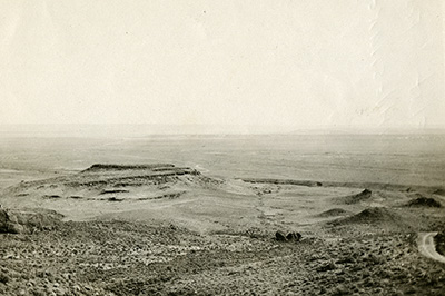
Dead Ox Flat from the head of Rattlesnake Grade in 1914. (Oregon State Archives)
WEISER, Ida., July 20, 1912 – Lured by the glitter of gold, prospectors for decades trod the shores of the mighty Snake in quest of wealth, from its waters, blind to the fact that no process of miner’s skill could wrest the treasure from the stream. It is there, but for years it has baffled those who sought to separate it from the sand and gravel of the river bed. The prospectors, reluctant, at last aban- doned their seeking and in their wake, came brawny men from the crowded east who said: “Here in this beautiful valley, we will make our homes and till the soil.
Choice to their eyes was Dead Ox Flat, which occupies the far eastern border of Oregon. Miles in length and breadth, and almost as smooth and level as a village road, it seemed a likely spot. Dense, high sagebrush assured them of the soil’s fertility, and these hardy pioneers took up their homesteads. They dug their wells and fought against the sagebrush and the sun, cleared a few acres, builded small shacks for homes, and struggled to wrest a livelihood from the soil. Some were successful beyond their fondest hopes. Others early gave up the struggle, but their places were taken rapidly. Finally many men obtained their patents to the homestead and numbers of them sold their deed for a pittance and moved on, little knowing that they were leaving fortune behind.
Dead Ox Flat blossomed and bloomed, but irrigated lands came into being in neighboring sections, and appeared so much more attractive that many of the “dry farmers” of the flat sought the easier way. Others stayed on, tilling their soil, with rain as their only moisture. Some were so successful that last year they harvested wheat running 55 bushels to the acre, but these were the rare, few, straggling exceptions, and the majority of the land owners on Dead Ox Flat required hundreds of acres to make farming profitable, while great stretches that had been homesteaded and sold lay idle and returned to sage-brush.
How It is Joined to Idaho, Dead Ox Flat, be it understood, is a great, wide plateau, rising sheer from the bed of the Snake River to a height of from 50 to 300 feet. It extends from the extreme western edge of the Weiser valley, many miles eastward, following the sinuous sweep of the Snake. It is joined to Idaho by a bridge which extends into the city limits of Weiser.
Then a few short years ago owners of land and settlers began to wish for water for irrigation. Engineers looked over the land and promptly told them that irrigation by gravity system was out of the question. Then came stories of irrigating with pumps. Powerful transmission lines, bearing vast quantities of electricity, were strung over Dead Ox Flat. Below them lay great tracts of the most fertile soil in Ithe northwest – soil which had produced as high as 55 acres of wheat under dry farming and still further below the Snake river flowed through its little canyon and carried tons of the water to the sea.
Here was the rich volcanic ash soil, with a fine substrata of gravel, providing excellent drainage, and there was the water, from 50 to 300 feet below, for irrigation. The power was plentiful. The next problem was to unite these three in a profitable combination.
First Efforts at Reclamation.
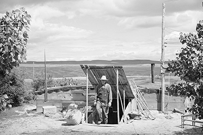
Ray Halstead, FSA (Farm Security Administration) rehabilitation borrower, pumping up a tire. Dead Ox Flat, Malheur County, Oregon (1941) Lee, Russell, 1903-1986, photographer
Some venturesome farmer whose lands were near the edge of the flat installed a small motor and pipeline. He started putting water on his acres, and they blossomed like the garden of Eden. He tried fruit trees, and they flourished. Alfalfa and almost every other soil product seemed striving to set a record for growth. Then the pioneer’s neighbor bought a small motor, and this was followed by small companies which owned large areas. The Mainland interests installed a small pumphouse and equipment, and their 440 acres became wealth producers.
Then came the great Snow-Moody Project, which undertook to deliver water to thousands of acres from a huge pumping plant. Young orchards began to dot the landscape, and the whole section took on a new aspect. Gold, for which the prospectors had sifted the same sand decades before; gold, for which the homesteaders had sought in vain, was in sight, and with this discovery the greatest era of rapid development ever witnessed was under way, for it was discovered that power could be supplied so cheaply and land benefited so greatly that the pump systems, In cost, were superior in many cases even to the gravity systems. As a result, this year is producing a tremendous transformation. Within six months, The face of Dead Ox Flat has become entirely changed and ere six months more have been added, it will be unrecognizable even to those who knew it intimately AS long as 18 months ago. Wonderful in land the rapidity with which it is changing, the land is becoming the green and beautiful tint of growing things and great tracts of sagebrush and wide areas of grain are giving way to the budding young orchard, the thriving berry and garden patches and the crops which make the small tract desirable to land-hungry hordes.
Ten thousand acres will be placed under irrigation this year alone in three separate projects. Realizing of that in watering their land, as in many other things, co-operation, would reduce the individual burden to the settlers formed districts under the friendly, encouraging law of Oregon undertook to reclaim the land. In addition to the great area whose productivity will be increased many fold by irrigation this year, other projects under way will add still more to the number of acres to be watered.
On Dead Ox Flat today, it is no uncommon sight to see standing proudly on the plain, a beautiful, modern bungalow home, handsome barn and other spick and span new out- buildings, all newly fenced with from 40 to 100 acres in orchard trees and other crops, all planted since the last winter’s snows vanished. It is no uncommon sight to see a brilliant landscape, with every evidence of profit, where a year ago there was nothing but sagebrush.
Vast stretches of raw land have given way to the plow and the cultivator and under the welcome influence of water have been planted to crops which spell profit and success.
For Greater Development.
Organized early last spring. Snake River District Development association was formed by the land owners embraced in its borders and within a few short weeks all preliminary details had been completed and the contract had been awarded for the construction of the pumping house and irrigation plant which is to deliver water up to 2500 acres be- fore next September. Much of this land, already is under cultivation by dry farming methods but much more has been producing nothing but the volunteer sagebrush. With the formation of the district, the removal of sagebrush and preparation of the land for the more profitable crops began. Homes will be ready for occupation and small tracts will be ready for intensive farming methods at the instant, the big pumps are turned on and water begins gushing through the pipes up the incline and on to the waiting, fertile soil of Dead Ox Flat.
Only a few miles from Weiser, the owners of an area, 1500 acres in extent, decided to have water. They formed their district but did not incorporate. They asked no aid of outside capital; they sought no promoter. Their officers were chosen from their own number; farmers all and as a result water was turned on last May to the Crystal Improvement district through one of the most attractive pumping plants in the country at the extremely reasonable cost of $20 per acre. This covered all the expense of organization and installation. The annual cost for the use of the water is merely nominal.
This Crystal plant is owned and was built by the farmers themselves. In many respects it is unique and a model. Through two electric motors, aggregating 125 horsepower, water will be delivered entirely in pipes.
Oher Districts Being Settled
Sunk in the pumphouse and surrounded by thick walls of concrete, the two powerful motors are located at water level, giving greater force for the 40-foot lift necessary to put water on the highest land in the district. The main supply pipe which is 20 inches in diameter, extends for a distance of 4000 feet with smaller pipes radiating from it at intervals.
Adjoining this district, is the Snow Moody Project covering 8000 acres on the Oregon side of the river between Payette and Weiser. Abutting the Snow Moody Project on the north is the Snake River Improvement district. Contracts call for its completion by September 15. It will require, in its construction, a mile of 36-inch pipe, and a mile and a half of 16- inch pipe which will carry the water 80 feet to the highest point of distribution from whence it will reach 2500 acres.
Within half a mile to the North of the Snake river district project is the Riverside pumping plant which covers 2000 acres. Farther north at the lower end of the flat, and a little west of Weiser, is the Porter plant which supplies water to 600 acres.
Thus, within a single year, all of these pump irrigation systems will solve the problem of the early gold- seekers on at least 14,696 acres of land as fertile as any to be found in the northwest. Climatic conditions are ideal and growth of crops already planted assures success. The great speed with which the sagebrush and the dry farming crops are giving way to the profit-bearing orchards, and gardens is an amazing example of the progressive pace which the farmer hits, once he sees the way.
August 5, 2014 -The entire area North and Northwest of Ontario, Oregon is part of Dead Ox Flat. The town of Dead Ox is a bit harder to pin down directly, but was likely only a few miles away from Ontario.
Sometimes city names pop up in the most interesting of places. While looking through vintage photographs on Shorpy.com I came across this interesting photograph.
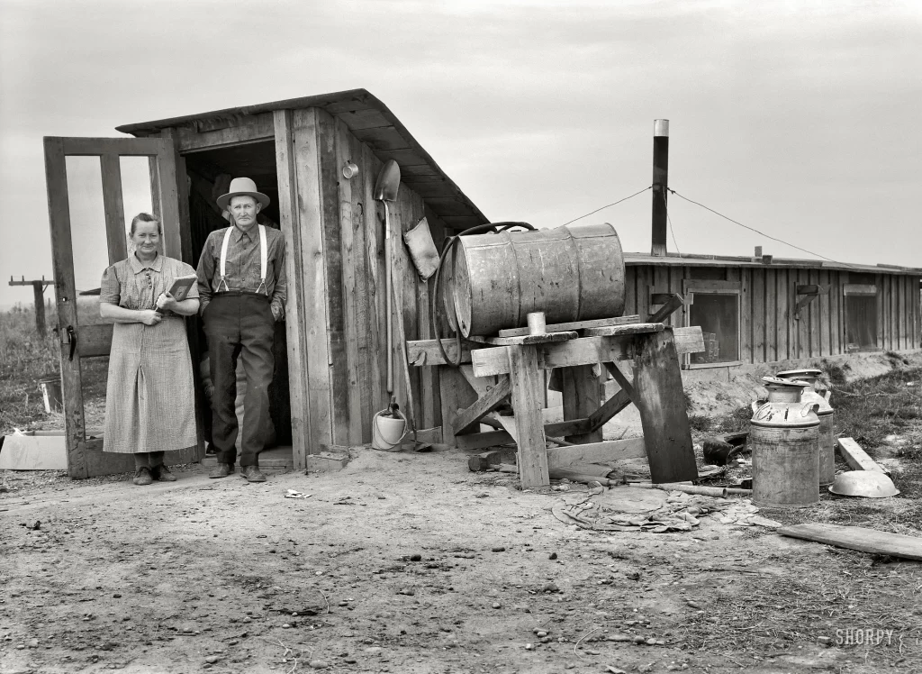
Mr. and Mrs. Wardlaw at entrance to their dugout basement home
The caption says: “October 1939. “Mr. and Mrs. Wardlaw at entrance to their dugout basement home. Dead Ox Flat, Malheur County, Oregon.” Medium-format nitrate negative by Dorothea Lange for the Resettlement Administration.”
I’ve never heard of Dead Ox Flat so decided to look more into it. The origin of the name is rather obvious once the location is placed in Oregon’s Malheur County. Located as it is north of Ontario Oregon, this is the Oregon High Desert homesteaders, crackpots, hopeful real estate investors, the United States Government, and the Oregon State Government envisioned when it was first found that given enough water, the land supported good crops.
There is no history of the area before 1902 that I can find. The area was no doubt surveyed for beavers by both the Hudson Bay Company and the Northwest Fur Company in 1818 during a survey of the nearby Boise Valley. During the 1860’s through 1900’s, White Settlers tried to farm this area, most were unsuccessful at best. Since it’s near the Snake River it was thought that there was enough water, or canals of some sort could be built and farming would flourish. Fort Boise and nearby Ontario both grew quickly during this same time period, but mostly because they were directly on the Oregon Trail which later became a Stage Coach Route, before being replaced by the railroads.
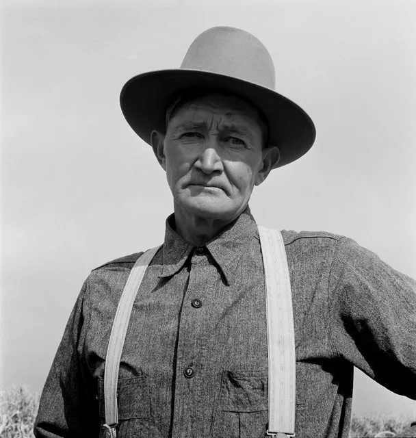
(Click Image to Enlarge) Mr. Wardlaw – Farmer from Dead Ox Flat
The US Department of the Interior started investigating damming up rivers in Central and Eastern Oregon in the first decade of the 1900s. This announcement caused yet another land rush to Oregon. Just as it happened in the 1860’s with the announcement of gold, people world wide immigrated causing new towns and tent cities to popup over night. Land spectators snapped up any piece of available land and resold it at profit to new settlers. For instance, in 1909 the Government’s mere consideration of building “Hole in the Ground” Dam in Christmas Valley caused at least ten different towns to pop up. These towns were big enough to warrant post offices, but eight were completely gone by 1925.
In the meantime, local governments, private corporations and even individuals attempted to build pumps strong enough to bring water into the valley. By 1916 plans to dam the Owyhee River were finalized, but the project did not get under way until April 1927. One of the side effects was the creation of the Dead Ox Flat water district, a pumping station and a 61 mile pipeline to Dead Ox were built in 1937.
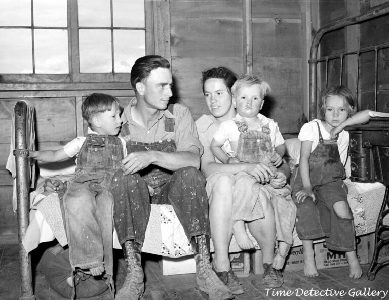
The Civilian Conservation Corps was involved in the last part of this project, but as part of the “New Deal” a young female photographer named Dorothea Lange came to the area in 1939. She took some of the Depression Era’s most iconic photos, and spent time taking photos in and around Dead Ox Flat.
Today the area’s population seems to be about 1,500, almost evenly split between male and female residents. Dead Ox Flat no longer has it’s own post office, and is considered a suburb of farming community, Ontario Oregon. Huge farms cover the entire valley. Other then the pump building, and the pipes from the dam, little of Dead Ox Flat’s history remains.
Little remains of Dead Ox Flat, a tiny town out on the sagebrush prairie just outside of Ontario. It was a tiny farming community born from practically nothing but a will to settle the arid West and make the land productive. In the early 1900s, local governments and private corporations tried building pumps strong enough to bring water into the desolate valley. The town owes its origin to the Dead Ox Flat water district. This amounted to a pumping station, canals, and a miles-long water pipeline built in 1937 by the Civilian Conservation Corps.
Few records of this short-lived town exist, other than the photos taken by Dorothea Lange. Lange is now famous for her depression era photographs and her work for the Farm Security Administration (FSA). President Roosevelt created the FSA in 1937 to aid poor farmers, sharecroppers, and migrant workers. It promoted government planning and intervention to improve living conditions in rural America.
The FSA was one of the New Deal’s most progressive and controversial agencies. It moved poor farmers onto more productive land, promoted soil conservation, provided emergency relief, and loaned money to small farmers. In so doing, Dead Ox Flat was born. Practically nothing is left of the town today. The dugout homes and sagebrush hay barns are all gone. The only things still standing are the old water pipes and ancient pump building.
More Dead Ox Flat Photos:
A man exits the basement house of Mrs. White in Dead Ox Flat in 1941
If you have questions about this page, want to start or join a discussion about it, or add new information, please visit our Facebook Group, “Weiser Area Memories.”