W-Logo
W-Logo
WeiserAreaMemories
Weiser-ites-2
W-Logo
W-Logo
Too many Names on the A-Z Lists? 
 Now easily Search by Name!
Searching Tip – Use the least amount of words necessary, and choose the correct name from the results.
(e.g. “Jones,” not “T Jones,” “T. Jones,” “TS Jones,”  “T.S. Jones,” “Ted Jones,” etc. – just “Jones.”)
A-Z Lists:
 
People
 
Places
 
Events
 

Owyhee Project

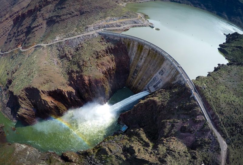
Owyhee Project. Aerial of Owyhee Dam and Morning Glory Ring Gate, also known as the Glory hole. Heavy water year. Heavy spill .  04-04-2017 BOR Photo by Kirsten Strough.
Owyhee Dam
************************************************************************************************************************************
**************************************************************************************************************
********************************************************************************************
****************************************************
********************************
About Us
The Owyhee Irrigation District is a quasi-government organization, that lies West of the Snake River in Malheur County, Oregon, whose primary purpose is to supply irrigation water to over 67,200 acres of land in eastern Oregon including Adrian, Nyssa, and Ontario, Oregon. The key features of the project are the Owyhee Dam, the Dunaway Pumping Station on the Snake River about 11 miles southwest of Adrian, Oregon, and the Dead Ox Pumping Station outside of Ontario, Oregon heading towards Weiser, both of which act as a diversion structure.  Owyhee Irrigation District is part of the project works that includes over 900 miles of canals, pipelines, laterals and drains, 2 pumping plants, and 3 hydro-electric facilities.   In 2008 the valley celebrated the 75th anniversary of the dedication of the Owyhee Dam.
Operating Agencies
Project works, except Owyhee Dam and related works which were retained and operated by the Bureau of Reclamation, were transferred to the water users (represented by the North and South Boards of Control) in 1952 for operation and maintenance. Two years later, Owyhee Dam and related works also were transferred to a Joint Committee comprised of representatives of the North and South Boards of Control for operation and maintenance. On July 14, 1989, all irrigation entities of the North Board of Control merged into the Owyhee Irrigation District and the North Board of Control was dissolved. Owyhee Dam is now operated by the Owyhee Irrigation District in cooperation with the South Board of Control.
From Owyhee Irrigation District
Our History
In 1925, after studying various reports and plans made by the Government engineers, State cooperative boards and private companies, after conducting further investigation of their own, the Bureau issued a feasibility report recommending construction of the Owyhee Project. Work began on the storage dam and canal system in 1928, and the first water was delivered to the project lands in 1935. The Owyhee Project was designed to supply water to the entire project area by gravity flow from Owyhee Reservoir. But, because the Owyhee River’s flow is frequently too low to supply the necessary water, privately-constructed pumping plants provide Snake River water to lower-lying project lands. These plants are operated under a 1936 contract between the Bureau of Reclamation and several irrigation districts. The completed Owyhee Project lies west of the Snake River in Malheur County, Oregon, and Owyhee County, Idaho. The project provides a full irrigation water supply to 105,249 acres, and a supplemental supply to 13,000 acres. Of the 118,249 acres total, 71% is in Oregon, the remainder in Idaho. The project encompasses 1,831 farm units and 8 towns.
From Wikipedia – the free encyclopedia
If you have questions about this page, want to start or join a discussion about it, or add new information, please visit our Facebook Group, “Weiser Area History.”
************************************************************************************************************************************
**************************************************************************************************************
********************************************************************************************
****************************************************
********************************
If you have questions about this page, want to start or join a discussion about it, or add new information, please visit our Facebook Group, “Weiser Area Memories.”
Also See Dead Ox Flat
Also See
Categories